Modern Science Gets Inside the Heads of Easter Island

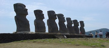
Creating topographical maps that represent the lay of the land used to be a painstaking process that took years of travel and further hours of pouring over collected data. The resulting map, while functional, paints a distorted representation of the actual lay of the land. This baseline understanding of a landmass unlocks the history of its changing terrain and inhabitants, but to a fault. On Rapa Nui, or Easter Island, where questions about its many statues remain unanswered, the shortcomings of old techniques fly in the face of today’s archaeologist.

Advanced Mapping

Modern topography goes beyond the simple record of elevation and land features. Today’s language around the subject concerns geospatial data sets. These comprehensive feeds are the result of thorough research collected using updated techniques such as the near-infrared sensors and the orthophoto. Unlike a typical aerial photograph, the orthophoto accurately depicts a photographic map. Where aerial photos cannot account for tilted shots that create image displacements, an orthophoto creates a uniform scale. The difference between the two may be nearly imperceptible to the human eye, but the photographic map’s value to the researcher leads to more complete data.

Unmanned and Unexpected

Unlike more populated parts of the Earth, Rapa Nui lacks a comprehensive geospatial data set. All known data collected by the human eye answers no questions about the history and reasoning behind the island or its iconic statues. A team of researchers from California State University Long Beach, led by professor of anthropology Carl Lipo, decided to approach this problem using commercial technology known as an unmanned aircraft system.

Unlike the popular quadcopter drones owned by private citizens, the UAS resembles a full-sized airplane. Equipped with a camera and controlled by a computer on the ground, the unmanned unit follows specific flight plans that allow for a much bigger picture with unsullied, inclusive data.

Lipo and his team used the UAS over the course of nine days to cover a section of Rapa Nui. Over the course of 26 missions, the team captured 26 different orthophotos and made strides in topographical and hydrological data. They reported immediate results and observed unique insights based on this data. Lipo reported that, based on the information they gathered, Easter Island’s ancient culture positioned its statues to signify nearby water and not for visibility as previously assumed. The UAS performed so well that CSULB decided to continue covering the entire island in future projects.

A Big Year for GPS

The Global Positioning System, better known to its users as GPS, exists as a complex interlocking network of satellites, operators, and users. Last July 17th, GPS turned 20 years old. In a mere two decades, the technology has changed the way we navigate and orient ourselves. It remains the standard for accuracy in positioning and continues to grow. In fact, this year saw several leaps forward for the famous government program.

The 2nd and 19th Space Operations Squadrons

Referred to as 2 and 19 SOPS, “Team Black Jack,” or the 50th Space Wing, these two integral units consist of the men and women who run GPS from Schriever Air Force Base. While there are many SOPS at Schriever, only two are concerned with GPS. You could think of 2 SOPS as ground control, performing commands and carrying out missions, whereas 19 SOPS dedicates its time to launches and sustaining the operative capacity of satellites in orbit.

The 50th Space Wing’s profound impact on our world goes largely unnoticed, but this year, they received due recognition.

Public Recognition and Events

Last year, the 2 and 19 SOPS took part in multiple public events, even hosting GPS week in February. The educational event involved a tour of Schriever for many middle and high school students and the 2nd squadron visiting local schools in an outreach program. Later in the year, the city of Colorado Springs (near where the program is based) honored the 2 and 19 SOPS on the program’s 20th birthday by declaring July 17th “GPS Day.” With more publicly, the 50th Space Wing and GPS garnered attention on an episode of “60 Minutes.”

Continuing Expansion

In just 2015 alone, the 2 and 19 SOPS launched and assumed command of three new satellites. After three months of preparation, Team Black Jack expanded its network from 8 to 11 total operational satellites. This may mean new and unprecedented advances in GPS’s precision and timing capabilities in the years to come.

The Historical Side Of Land Surveying

Historians aren’t quite sure who made the prehistoric monument at Stonehenge, but they know that early surveying equipment was used. In fact, most ancient civilizations relied on simple geometry and surveying tools to establish land borders and boundaries for building, farming, and city planning. The Romans, for example, built the most advanced system of roads the world had ever seen with the help of land surveyors. Here’s a brief look back at how the profession has changed since those early days.

Equipment: Development and Improvement

Before the 18th century, most surveyors used ropes and chains to measure distance. The great leap forward occurred in 1787, when the first precision theodolite was introduced. The instrument simultaneously measures angles on both vertical and horizontal planes. It helped surveyors quickly and accurately measure angles to distant points, which was invaluable for map making.

But as important as the theodolite was, surveyors still had to manually measure distances to ensure precision. It was not until electronic distance measurement (EDM) was developed in the 1950s that they could finally put away their ropes and chains. The device utilizes microwave transmitters and receivers to determine long distances. Building on this advancement, instruments that measured both distance and angles came on the scene in the 1970s. Known as total stations, their speed and accuracy have continued to improve at an impressive pace. Modern stations can even be operated by remote control!

At present, the theodolite and the total station are considered essential pieces of equipment for professional surveyors. Although GPS technology has come a long way in recent years, it does not yet provide the accuracy and precision professionals need to do their job. As such, GPS equipment is rarely used to the exclusion of more trusted surveying tools.

Measurement Conversions

Because most surveying tools use the metric system, U.S. surveyors must convert their measurements from meters to feet (1 meter = 3.28 feet). Even more confusing is a unit of length and area known as a rod. Used primarily in older property deeds, one rod is equal to 16.5 feet. For federal surveyors who complete U.S. public land surveys, an ancient measurement unit called a chain is still in use. Originally consisting of 100 iron links that were nearly eight inches long, a standard chain is 66 feet in length.

Although the tools and technologies have changed, many ancient units of measurement are still in place today. For the average residential surveyor, it is often enough to simply convert metric measurements to imperial (U.S.) ones. But for federal surveyors, a more complex system based on ancient measurements is still in use.

Five Historical Figures Who Were Land Surveyors

Photo Of George Washington On Mt. Rushmore - Garrett and Associates

In addition to being brave men and women who accomplished monumental things, several famous names from American history were also land surveyors. Here are five of them.

George Washington

Not only was he a great general and the first U.S. President, but George Washington was also an experienced land surveyor. Starting as a teenager, the strapping lad would go on to survey over two hundred tracts of land in his life. The skill served Washington well, helping him acquire more than 65,000 acres of land in thirty-seven locations. At the time of his death, he was one of the wealthiest landowners in Virginia.

Thomas Jefferson

Another U.S. President from Virginia, Thomas Jefferson was a Renaissance man who explored numerous fields of knowledge—one of which was land surveying. Appointed County Surveyor for Albemarle County, Virginia in 1773, he would use the skills he acquired in that post as Secretary of State (under President Washington). According to historians, Jefferson helped manage teams of federal land surveyors who were responsible for the orderly settlement of the frontier.

Abraham Lincoln

Before he was a small-town lawyer and a U.S. President, Abraham Lincoln was a local land surveyor. Appointed Surveyor for Sangamon County, Illinois in 1833, young Lincoln was responsible for surveying roads, boundary lines, town lots, and settling boundary disputes.

Daniel Boone

Not every famous land surveyor was also a U.S. President. Daniel Boone was a early American explorer, woodsman, and pioneer. His intimate knowledge of the wilderness that is now Kentucky made him the few men qualified to survey the land of that region. As such, he was named Deputy County Surveyor for Lincoln County, Kentucky in 1783.

Lewis & Clark

Shortly after President Thomas Jefferson completed the Louisiana Purchase in 1803, he commissioned an expedition to explore the new lands. Captain Meriwether Lewis and his friend, Second Lieutenant William Clark, were put in command. Both men had studied surveying; Lewis had been taught the subject by President Jefferson, while Clark had learned land surveying and mapping in the army. On the expedition, Lewis was responsible for most of the celestial observations, while Clark drew most of the maps.

A challenging profession, land surveying was instrumental to the creation of every modern nation. Because the United States was once an uncharted wilderness, many of its most famous citizens studied the science at some point. Some of them even accomplished great things with the help of their training.

Photo Credit: James Hawley

Land Surveying History: More Than Meets the Eye.

Garrett & Associates

Wherever monuments were built in the ancient world, wherever man raised his eyes to the heavens and built on earth, a surveyor was there. Whether the circles of Stonehenge, the pyramids of Egypt or South America, the ancient temples of Greece and Rome, all were laid out with specific relationships that codified the relationship between the people, their government, and their deity.

The earliest recorded surveys were conducted by the ancient Egyptians. Famous for their monuments, they are perhaps best known now for the only remaining structure of the original “Seven wonders of the world,” the Great Pyramid of Giza. For 3,800 years the tallest structure in the world, it’s almost exact north-south orientation and precise geometry are a testament to the surveyors who laid out the plan using little more than knotted ropes and plumb bobs. But the Egyptians used surveying for more than establishing their monuments, there are 4,000 year old clay tablets establishing property boundaries for ownership and sale of land. These provided the basis for the Egyptian economy, for agriculture, and for trade throughout the region. As the Nile river flooded each year, washing away boundary markers, surveying was an annual necessity for the continuance of a civil society.

As Greek civilization grew they looked to Egypt, as the Romans in turn looked to Greece. Around 522 B.C.E. it was the engineer Eupalinos who dug the underground aqueduct that bears his name on the island of Samos. Over a thousand meters in length, the tunnel was dug through solid rock from both ends simultaneously, tunneling through a mountain to provide an uninterruptible water source for the town. Without exact measurements the two tunnels may have never met, but Eupalinos managed the feat with tremendous accuracy, using nothing more than Geometry and a perhaps a forerunner to the surveying instrument invented by the Greeks, the Dioptra. A disc leveled by screws and inscribed with angles, the dioptra could be used to determine the angle between two distant objects from a fixed point.

The Romans adapted the Dioptra, and well as a Mesopotamian tool they called the Groma. Together with spirit levels and odometers, these tools provided surveyors and engineers with all the information necessary to lay out colonies, build cities and monuments, aqueducts and roads, some of which are still in use today. At it’s height, the Roman water system used eleven separate aqueducts spanning almost 400 kilometers to bring over one million cubic meters of clean water into the city every day.

It wasn’t until the 16th century that the Theodolite came into use. A precision instrument for measuring angles in both the horizontal and vertical planes, it has survived into the modern era with continual upgrades. In the United States, George Washington, Daniel Boone and Lewis and Clark are but a few of the surveyors whose use of the theodolite had profound impacts on the young nation’s history. In civil engineering circles, Mt. Rushmore is often jokingly referred to as “three surveyors and some other guy,” though there is a move afoot to consider Theodore Roosevelt a surveyor as well. His famous 1913-1914 map-making expedition to Brazil resulted in a river there being named after him (Rio Roosevelt, sometimes known as Rio Teodoro) and almost cost him his life.

Modern theodolites now come equipped with infra-red based measuring devices, software, and may even be remote controlled. Though the technology has changed, the goal remains the same as it has been throughout land surveying history: to quantify the unknown.